After World War 1 ended, there was a renewed interest in conquering Mount Everest, particularly among the British adventuring set that had lost out on reaching the North and South Poles first. In order to help finance and organize summit attempts, the Royal Geographical Society and Alpine Club created the Mount Everest Committee which consisted of ranking members of both groups.
As maps and general information about Mount Everest were lacking at the time, the first expedition was setup in 1921 for the purpose of surveying possible routes up to the peak. The group consisted of nine men, George Mallory among them, and a journal recounting their explorations was published not long after their return to England. It can be read online thanks to Google Books.
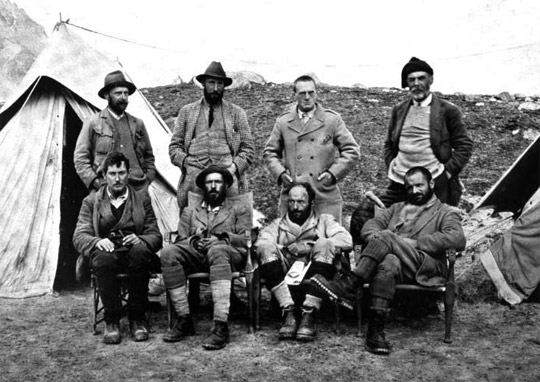
Members of the expedition, clockwise from the top left: Wollaston, Howard-Bury, Heron, Raeburn, Mallory, Wheeler, Bullock, and Morshead. Not pictured – the ninth man, Dr. Kellas, passed away while en route to the mountain.
Some parts of the introduction by Sir Francis Younghusband are quite good:
It stands to reason that men with any zest for mountaineering could not possibly allow Mount Everest to remain untouched. The time, the opportunity, the money, the ability to make the necessary preliminary preparation might be lacking, but the wish and the will to stand on the summit of the world’s highest mountain must have been in the heart of many a mountaineer since the Alps have been so firmly trampled under foot. The higher climbers climb, the higher they want to climb. It is certain that they will never rest content till the proudest peaks of the Himalaya are as subdued and tamed as the once dreaded summits of the Alps now are.
In the second half of the book, Mallory describes his explorations of the Northern Approach and climbing up to the North Col, which would later become a standard route for mountaineers to take. In one section he also describes his first view of Mount Everest:
It was a prodigious white fang excrescent from the jaw of the world. We saw Mount Everest not quite sharply defined on account of a slight haze in that direction; this circumstance added a touch of mystery and grandeur; we were satisfied that the highest of mountains would not disappoint us. And we learned one fact of great importance: the lower parts of the mountain were hidden by the range of nearer mountains clearly shown in the map running North from the Nila La and now called the Gyanka Range, but it was possible to distinguish all that showed near Everest beyond them by a difference in tone, and we were certain that one great rocky peak appearing a little way to the left of Everest must belong to its near vicinity.
It’s only unfortunate that the maps that Mallory and Bullock produced weren’t included in the scan of this particular book. Continue reading more.
Comments are closed.